It’s been one year since Canada completed its $180.4-million investment to modernize its weather radar system across the country. The efforts are being met with excitement on the part of meteorologists who say the changes will enable earlier warnings about short-term, severe weather.
Next up, Budget 2024 committed to invest an additional $6.9-million over five years, giving the Meteorological Service of Canada the opportunity to continue work on an early warning system for extreme weather events with a focus on floods and storm surge.
“It’s about getting more information so that we can issue alerts and Canadians can use that information to protect themselves,” says Environment and Climate Change Canada (ECCC) meteorologist, Gerald Cheng. “Severe weather affects everybody at some point in their lives. It has some big economic consequences. It has social impacts. So having better equipment, instruments to detect severe weather allows us to really provide better information to the public.”
New systems, early warnings and better data
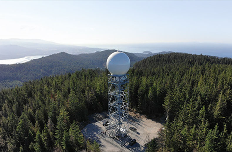
The weather radars, according to the ECCC, represent a significant advancement in forecasting technology. They provide updates every six minutes instead of every 10 and the range of the new radars has been extended 80 kilometres to 330. According to Cheng, the area covered by the 32-radar network is now over four million square kilometres, up from just over one million.
In addition to replacing the government’s existing 31 radars, another was added in the Lower Athabasca region of Alberta and a training radar – used to train technologists and to test new hardware and software prior to their deployment to other radars – was also added near Egbert, Ontario. The first radar was installed in Radisson, Saskatchewan in the fall of 2017 and the final radar was installed on Halfmoon Peak, British Columbia in August 2023.
The new radars include a few new features including dual polarization – which allow meteorologists to distinguish between different types of precipitation (rain, versus hail or snow), and also enables better identification of non-meteorological targets, including birds, bugs and tornado debris.
The second feature, Cheng says, is the extended Doppler range, which he says will give Canadians additional lead time in the event of severe weather. The radars are also more highly powered, allowing much better storm penetration. Where patches of heavy rain would weaken the signals previously, the current installation allows meteorologists to see into the storms themselves.
The update frequency (from 10 minutes to six) and the extended range are both significant developments, agrees Daniel Henstra, professor of political science at the University of Waterloo and co-lead of the university’s climate risk research group.
His work for the University of Waterloo and the Waterloo Climate Institute, has included work to inform the development of the government’s national flood insurance plans.
“The significance of this is that the technology has radically advanced. The update frequency really matters because it gives meteorologists a picture of how quickly a system is moving,” he says. “Adaptation is about changing behavioural patterns for individual Canadians. Part of that is being attuned to these weather predictions.”
The data is also expected to give Canadians – including governments and perhaps insurers too – ideas about where hotspots of risk exist.
Mitigation programs also require change
In these matters Henstra says the mitigation radars are a step in the right direction. “With the accumulation of high-resolution data, we can identify hotspots where major extreme weather events happen more frequently than others,” he says, and “target federal investments more rationally into high-risk areas.”
He points out that currently there is scarcity of funds to spend on projects. “We can’t possibly spend money everywhere. What the government of Canada should be doing is identifying the highest risk areas and investing the money there,” he adds.
In describing the granting system the government uses, however – funding programs are created for mitigation but access to these funds is generally granted through application-based processes – it is also easy to come to the conclusion that radars and additional data might be useful in making changes to these programs, as well.
“We’re not necessarily investing in the highest risk areas, what we’re doing is rewarding municipalities that have a good grant writer on staff who can write a compelling narrative around why the money is necessary,” Henstra says. “I’m not saying that we shouldn’t invest that money but there are probably higher risk areas where that money would go further.”
Henstra’s work has also advocated for a more thoughtful approach to rebuilding – calling for flood insurance plans being developed by the federal government, to be designed in such a way that funds are not used to rebuild in high-risk areas, for example.
Although the government’s flood insurance program remains focused on addressing the protection gap in high-risk flood areas, Henstra has also suggested in Waterloo Climate Institute policy briefs, that having the government enter the insurance market could also be an opportunity to explore new technologies, including radar, and coverage models that create market benefits beyond households in high-risk flood areas.
Insurance: a business about data
While Canadians will be making use of the radar warnings in the immediate term, hopefully to modify their behaviours in such a way that losses are mitigated to a degree, insurance companies, meanwhile, will likely be looking at the resulting new data with some interest in longer-term applications.
“They’re constantly adjusting their pricing to make sure that they’re making money. Otherwise they would just exit those markets,” Henstra says. “It’s always been a business about data. Current and accurate data is a really important ingredient for ensuring that insurance is priced optimally. And by optimally, I mean it needs to be at a level that people are willing to pay.”
Investment underway to improve floodplain mapping
In response to the Insurance Portal’s inquiries about where the $6.9-million will be spent when it comes to the government’s focus on flooding and storm surges, meanwhile, the ECCC says it launched a comprehensive coastal flooding prediction and alerting system in May 2024. They also note that advisories and warnings about overland flooding events are the purview of provincial and territorial authorities.
“For these advisories and warnings, provincial and territorial partners draw on the cooperatively managed national hydrometric program,” a spokesperson for the agency said. “ECCC works closely with these partners to improve the generation, sharing and dissemination of hydrometric information.”
They say the agency has updated floodplain mapping best practices, including an update to the federal Hydrologic and Hydraulic Procedures for Flood Hazard Delineation, in collaboration with Natural Resources Canada and Public Safety Canada. “This funding will allow ECCC to continue to support and promote best practices floodplain mapping with provincial and territorial stakeholders,” they add.